
About Us
Olkalou Constituency
MISSION: To coordinate activities for the empowerment of constituency citizens through prudent management, and effective and efficient utilization of funds allocated to the constituency”
VISION: A renowned Constituency in advocating for all round socio-economic development and sustainability
Wajir West Constituency is a featureless plain and lies between 150 metres and 460 metres above sea level and along latitude 1°45'N and longitude 40°4'E. Its Altitude is 244 m (801ft.). The constituency is prone to seasonal flooding during the rainy seasons which makes roads impassable. The constituency has seasonal swamps which together with drainage lines serve as grazing zones during dry season and for cultivation during the rainy seasons. The seasonal swamps are in Lagboghol area. The constituency is generally covered with young sedimentary rocks with loamy soils.
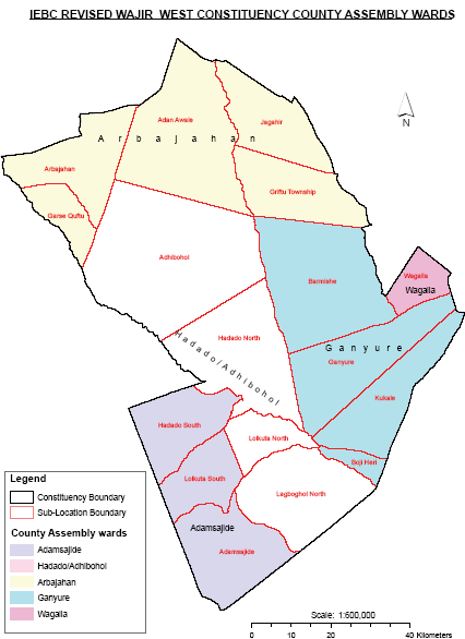
The constituency is one of the eight sub-counties of Wajir County. The others are Wajir East, Tarbaj, Eldas, Wajir North, Buna, Habaswein and Wajir South. The Constituency measures 10,043.6km2 and is made up of six (6) Divisions (Griftu, Arbajahan, Lagbogol, Hadado, Ademasajida and Wagalla
Wajir West Constituency is rural based with a few peri urban settings such as Griftu, Hadado, Ademsajida and Arbajahan. Currently, the Constituency has two (2) sub-counties namely, Wajir West and Hadado.
The constituency is located in Wajir County and borders four (4) constituencies, namely: Wajir East to the East, Eldas to the West, Isiolo South to the North and Wajir South to the South
Access NG-CDF Information on your Mobile


County Assembly Wards in Olkalou Constituency:
Arbajahan Ward
- County Assembly Ward No.:
- County Assembly Ward Name: Arbajahan
- County Assembly Ward Population (Approx.):
- County Assembly Ward Area In Sq. Km (Approx.):
- County Assembly Ward Description: comprises part of
Hadado/Athibohol Ward
- County Assembly Ward No.:
- County Assembly Ward Name: Hadado/Athibohol
- County Assembly Ward Population (Approx.):
- County Assembly Ward Area In Sq. Km (Approx.):
- County Assembly Ward Description: comprises part of
Ademasajida Ward
- County Assembly Ward No.:
- County Assembly Ward Name: Ademasajida
- County Assembly Ward Population (Approx.):
- County Assembly Ward Area In Sq. Km (Approx.):
- County Assembly Ward Description: comprises part of
Wagalla/Ganyure Ward
- County Assembly Ward No.:
- County Assembly Ward Name: Wagalla/Ganyure
- County Assembly Ward Population (Approx.):
- County Assembly Ward Area In Sq. Km (Approx.):
- County Assembly Ward Description: comprises part of